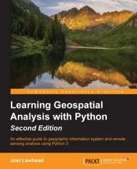
Learning Geospatial Analysis with Python, 2nd Edition: An effective guide to geographic information systems and remote sensing analysis using Python 3
4.5
بر اساس نظر کاربران

شما میتونید سوالاتتون در باره کتاب رو از هوش مصنوعیش بعد از ورود بپرسید
هر دانلود یا پرسش از هوش مصنوعی 2 امتیاز لازم دارد، برای بدست آوردن امتیاز رایگان، به صفحه ی راهنمای امتیازات سر بزنید و یک سری کار ارزشمند انجام بدینکتاب های مرتبط:
معرفی کتاب
کتاب Learning Geospatial Analysis with Python, 2nd Edition یک راهنمای جامع و کارآمد برای تجزیه و تحلیل سیستمهای اطلاعات جغرافیایی (GIS) و تجزیه و تحلیل سنجش از دور با استفاده از زبان برنامهنویسی Python 3 است. این کتاب برای کسانی که به دنبال استفاده پیشرفته از نرمافزارهای GeoSpatial و تحلیل دادههای مکانی هستند، منبعی ضروری به شمار میرود.
خلاصهای جامع از کتاب
این کتاب از همان ابتدای کار با اصول اولیه GIS آغاز میکند و به تدریج به مباحث پیچیدهتری مانند پردازش دادههای سنجش از دور، استفاده از ابزارهای قدرتمند مانند GDAL، PostGIS و شناخت و بهکارگیری تکنیکهای پیشرفته پردازش تصویر و تحلیل دادههای مکانی میپردازد. نویسنده در این کتاب نشان میدهد چگونه میتوان از Python برای حل مسائل پیچیده جغرافیایی استفاده کرد و با ارایه مثالهای عملی، خواننده را به درکی عمیق از قدرت حقیقی این زبان در این زمینه میرساند.
نکات کلیدی
- فهم عمیق نسبت به اصول پایهای GIS و سنجش از دور
- بررسی کاربردی کتابخانههای مهم مانند NumPy، SciPy، و Matplotlib در تحلیل مکانی
- آموزش شبیهسازی دادههای فضایی با استفاده از Python
- پوشش مباحث پیشرفتهای مانند یادگیری ماشین مکانی و پردازش تصویر
- نحوه کار با پایگاه دادههای مکانی و کاربرد ابزارهایی مانند PostGIS
جملات معروف از کتاب
«تحلیل مکانی، فراتر از نقشهها و نمودارها است؛ این هنر کاوش در دادههایی است که در جغرافیا نهفتهاند.»
«Python تنها یک زبان برنامهنویسی نیست؛ بلکه ابزاری است برای دیدن آنچه در محیط اطراف ما ممکن است مشاهده نشود.»
چرا این کتاب مهم است؟
اهمیت این کتاب در این است که به خوانندگان امکان میدهد تا از پتانسیلهای عظیم Python در تجزیه و تحلیلهای جغرافیایی استفاده کنند. با توجه به رشد روزافزون دادههای مکانی و نیاز به تحلیل سریع و کارآمد آنها، فهم و استفاده از چنین منابعی تبدیل به یک مهارت ضروری برای تحلیلگران داده و مهندسان GIS شده است. این کتاب به عنوان یک منبع آموزشی و عملی دقیقاً در زمانی مناسب به جامعه تحلیلگران ارائه شده است که آنها نیاز شدید به چنین مهارتهایی دارند.
Introduction to Learning Geospatial Analysis with Python, 2nd Edition
Explore the fascinating world of geospatial analysis with the power of Python, a versatile programming language. This comprehensive guide takes you on a journey through the intricate universe of geographic information systems (GIS) and remote sensing analysis, using Python 3. Focused on providing a practical understanding and application of geospatial concepts, this book is an essential resource for anyone interested in delving into the field of geospatial analysis.
Detailed Summary of the Book
The second edition of 'Learning Geospatial Analysis with Python' is crafted meticulously to cater to both beginners and experienced practitioners. The book begins with an introduction to basic geospatial concepts and gradually delves into more complex topics, offering insight into a variety of geospatial libraries and tools within the Python ecosystem. It covers topics such as reading, storing, and analyzing spatial data, developing geographic applications, and performing geospatial data analysis using Python.
Throughout the book, diverse real-world examples and step-by-step tutorials illustrate how to use Python libraries such as GDAL, OGR, Pyproj, NumPy, Scipy, and Matplotlib. The book guides you on integrating geospatial technology with Python programming to solve real-world problems, covering geospatial visualization, data handling, and advanced analytics. Whether it's mapping, spatial database management, or performing satellite data analysis, this book equips you with the skills necessary to harness the potential of geospatial data effectively.
Key Takeaways
- Gain a solid understanding of geospatial concepts and their importance in modern technology.
- Learn how to use popular Python libraries to handle geospatial data operations.
- Develop an ability to perform remote sensing analysis using real-world datasets.
- Build and deploy geospatial models to derive meaningful insights from your data.
- Become proficient in using Python for a comprehensive range of geospatial tasks, from basic mapping to complex spatial data analysis.
Famous Quotes from the Book
"Geospatial analysis is the synthesis of location in relation to the world around us; it's about fitting pieces into a puzzle and finding patterns that were previously invisible."
"Python's simplicity and the extensive support of geospatial libraries make it an excellent choice for anyone looking to unlock the power of spatial data."
Why This Book Matters
'Learning Geospatial Analysis with Python, 2nd Edition' stands out because it bridges the often complex gap between theory and practice in the geospatial domain. As the use of spatial data becomes increasingly vital across various industries, from urban planning to disaster management and climate change, understanding how to effectively analyze and interpret this data is crucial.
This book is pivotal as it introduces Python in the context of spatial data analysis and visualization, helping readers build real-world skills that are immediately applicable. The clear, structured approach and supportive examples invite readers to not only grasp fundamental concepts but also inspire innovation and exploration beyond the book.
Moreover, this second edition reflects the latest advancements and trends in the field, ensuring that readers are learning the most relevant and cutting-edge techniques available. Whether you are an aspiring data scientist, a seasoned geographer, or simply a Python enthusiast looking to expand your skill set, this book is a valuable asset in your educational journey.
دانلود رایگان مستقیم
شما میتونید سوالاتتون در باره کتاب رو از هوش مصنوعیش بعد از ورود بپرسید
دسترسی به کتابها از طریق پلتفرمهای قانونی و کتابخانههای عمومی نه تنها از حقوق نویسندگان و ناشران حمایت میکند، بلکه به پایداری فرهنگ کتابخوانی نیز کمک میرساند. پیش از دانلود، لحظهای به بررسی این گزینهها فکر کنید.
این کتاب رو در پلتفرم های دیگه ببینید
WorldCat به شما کمک میکنه تا کتاب ها رو در کتابخانه های سراسر دنیا پیدا کنید
امتیازها، نظرات تخصصی و صحبت ها درباره کتاب را در Goodreads ببینید
کتابهای کمیاب یا دست دوم را در AbeBooks پیدا کنید و بخرید
1507
بازدید4.5
امتیاز0
نظر98%
رضایتنظرات:
4.5
بر اساس 0 نظر کاربران
Questions & Answers
Ask questions about this book or help others by answering
No questions yet. Be the first to ask!


